
The big picture: The scope of the extreme weather stretches from coast to coast, with the National Weather Service's map of warnings and watches resembling an apocalyptic coloring book.
- The front and storm system will continue to send temperatures plunging everywhere except the Southwest, an extraordinary reach that will wreak havoc on holiday travel plans through this weekend.
Why it matters: The Arctic air, strong winds and an associated bomb cyclone could be deadly to anyone caught outside — and it's causing travel chaos on the roads and in the air during the holiday rush.
- This occurs when the atmospheric pressure falls by at least 24 millibars in 24 hours.
- In general, the lower the pressure is, the stronger the storm.
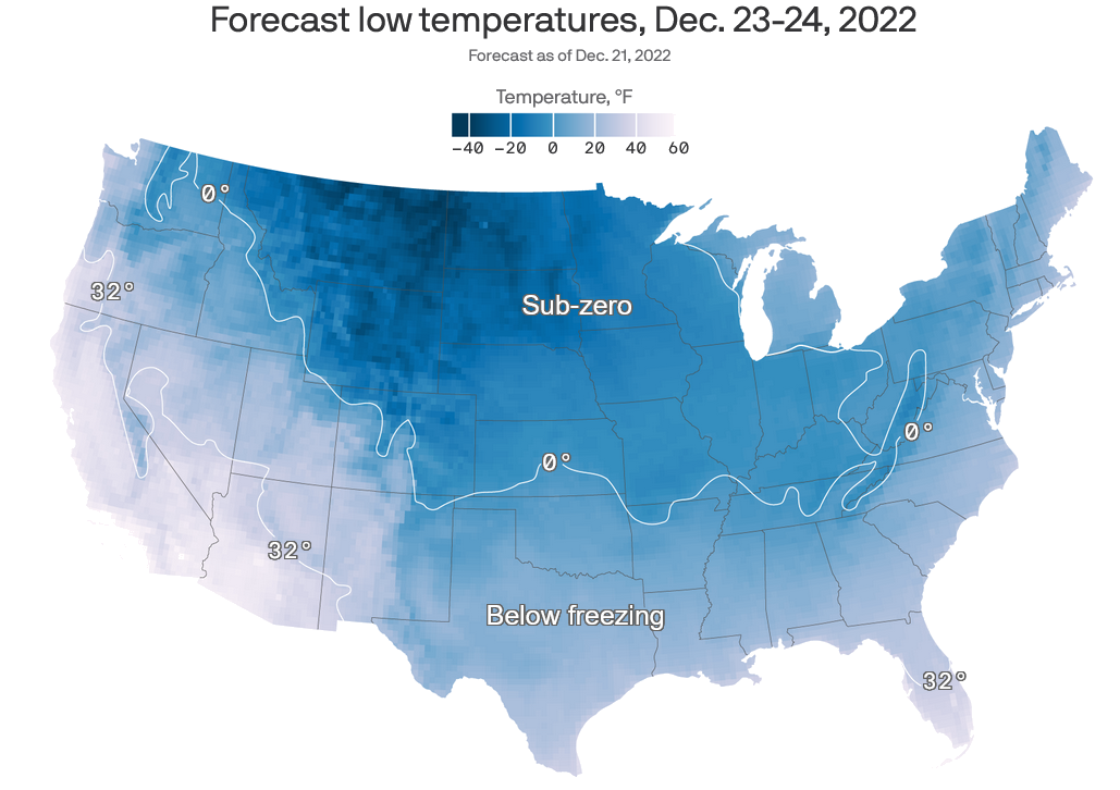
- Minus 70°F: Coldest wind chill seen so far during this event, in eastern Wyoming.
- More than 30 states: The area covered by wind chill warnings and watches, from the Canadian border to Texas Gulf Coast. Some areas may set records for their biggest temperature plunge in a short period of time, with computer models showing the potential for a "flash freeze" in multiple states.
- Not many all-time records are expected to be set during this event, although Casper, Wyo. managed to do so, at minus 42°F.
- In the U.S., most states east of the Rockies have been warming the fastest during winter, and cold spells have become less intense and shorter in duration.
Threat level: As of Thursday evening, about 325 million Americans were under winter weather warnings and advisories for heavy snow, frigid conditions and other winter weather hazards, stretching from the Pacific Northwest across the Plains and all the way South to the Gulf Coast.
- "The National Weather Service's Watch Warning graphic depicts one of the greatest extents of winter weather warnings and advisories ever," the NWS stated in a forecast discussion, calling the event "historic."
- Leaders from FEMA and the National Weather Service briefed President Biden on the winter storm. “I encourage everyone, everyone to please heed the local warnings,” Biden told reporters. “This is not like a snow day when you were a kid. This is serious stuff.”
State of play: The governors of Georgia, North Carolina, Kentucky and Wyoming declared states of emergency in response to threats from the severe weather system.
- About 8,000 flights around the U.S. were canceled Thursday, with nearly 3,000 facing delays.
- Roads were closed across Colorado on Wednesday night, from the town of Ault to the border with Wyoming, as Buckley Air Force Base, some 20 miles east of Denver, reported temperatures plummeting 46°F to 7°F in an hour.
- "At the forefront of the impressive weather pattern is a dangerous and record-breaking cold air mass in the wake of a strong arctic cold front diving southward across the southern Plains today and eastward into the Ohio/Tennessee Valleys by tonight."
- A storm is beginning to feast upon jet stream energy and on the contrast between milder air to the east and frigid temperatures to the west, and will intensify dramatically Thursday night and Friday as it tracks across the Midwest and into Ontario, Canada.
- More than 800,000 people have already lost power on Friday morning, with the most outages in New England and the Southeast, according to PowerOutage.us.
- People may continue to lose power between Friday and Saturday amid the cold, due to downed trees and power lines, particularly in the Midwest, Ohio Valley and Northeast.
- Some of the most extreme conditions will be felt around the Great Lakes.
- In Buffalo, 70 mph winds Friday are likely to drive a lake surge event that may push waters 4 feet above the shoreline, the NWS warns. The city is also expecting blizzard conditions, with as much as 3 feet of snow predicted.
- The surge will be part of what is known as a "seiche" event, where water sloshes from one side of the lake to the other, usually by strong winds or air pressure differences.

No comments:
Post a Comment