
10 Extraordinary Google Earth Timelapses
Show Earth's Transformation In 30 Years
Earth Time Lapse View from Space 1984-2012
Earth Time Lapse View from Space 1984-2012
Google has released these astonishing images showing data collected from the Landsat satellite from 1982 until 2012.
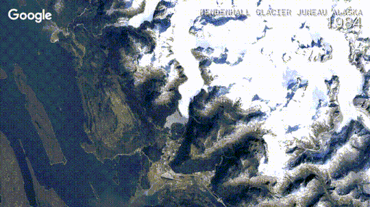
They reveal everything from man's impact on the desert as Las Vegas expands to the retreat of glaciers in Columbia.
Google worked with the U.S. Geological Survey (USGS), Nasa and Time to develop the site.
'Today, we're making it possible for you to go back in time and get a stunning historical perspective on the changes to the Earth's surface over time,' said Rebecca Moore, an Engineering Manager at Google.
Google Earth Shows How much the World has Changed in 30 years.
Earth Time Lapse View from Space 1984-2012

'Working with the U.S. Geological Survey (USGS), NASA and TIME, we're releasing more than a quarter-century of images of Earth taken from space, compiled for the first time into an interactive time-lapse experience.
'We believe this is the most comprehensive picture of our changing planet ever made available to the public.'
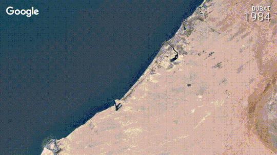
Google selected a range of images for the project, from the sprouting of Dubai's artificial Palm Islands, the retreat of Alaska's Columbia Glacier, the deforestation of the Brazilian Amazon to urban growth in Las Vegas from 1984 to 2012:
The images were collected as part of an ongoing joint mission between the USGS and NASA called Landsat.
Their satellites have been observing earth from space since the 1970s - with all of the images sent back to Earth and archived on USGS tape drives.
'We started working with the USGS in 2009 to make this historic archive of earth imagery available online,' said Miss Moore.
'Using Google Earth Engine technology, we sifted through 2,068,467 images—a total of 909 terabytes of data—to find the highest-quality pixels (e.g., those without clouds), for every year since 1984 and for every spot on Earth.
'We then compiled these into enormous planetary images, 1.78 terapixels each, one for each year.
'As the final step, we worked with the Create Lab at Carnegie Mellon University, recipients of a Google Focused Research Award, to convert these annual Earth images into a seamless, browsable HTML5 animation.'
Google says the maps are 'profound images'.
'Much like the iconic image of Earth from the Apollo 17 mission - which had a profound effect on many of us - his time-lapse map is not only fascinating to explore, but we also hope it can inform the global community's thinking about how we live on our planet and the policies that will guide us in the future.
The maps use Google's Earth Engine, which brings together the world's satellite imagery, with trillions of scientific measurements dating back almost 40 years.
Google has made it available online with tools for scientists, independent researchers, and nations.
the search giant says it hopes the resource will allow people to 'mine this massive warehouse of data to detect changes, map trends and quantify differences on the Earth's surface.'

No comments:
Post a Comment